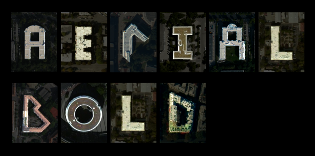
UBC Geography MSc student Joey Lee and his colleague Benedikt Groß have just launched a Kickstarter project called “Aerial Bold”. The two man army plans to build the first global map and typeface of the earth by traversing the satellite imagery of the entire planet and developing a set of image processing algorithms to find the alphabet shapes that are formed from the topology of buildings, roads, trees, lakes, etc.
While Aerial Bold is a fun project looking to turn “topography into typography”, it is an interesting example of what it means to be a geographer and what we as geographers can do with our tools and skills. This project shows us that GIS and remote sensing are not just tools to be used in an academic context, but skills that can be (ab)used and hacked to read space and time in new and exciting ways. Most importantly, the project shows us that the type of jobs that are open to geographers aren’t limited to the bullet point list on the side of the Geography Office, but rather that the possibilties are endless, especially for those interested to ‘read between the lines’.
How did this idea come about?
The project was inspired by our previous project: The Big Atlas of Pools. From this project we realized that there exists a big demand from the community outside of the geo sciences to derive features from satellite imagery. We wanted to engage a larger audience and to be more transparent about the ways in which you can map features from satellite imagery, and what things you might discover if you’re interested to step outside of the box.
What are you hoping to achieve through this project?
We’re hoping to inspire artists, designers, citizen scientists, and people not involved in data related fields to find features in aerial imagery and ways of feeding that information back into their communities, whether it’s to spark a discussion about a certain phenomena, to make a fancy data visualization project, or in general, just to add to a larger discussion about how and for what data can be used – especially those derived from aerial imagery.
How has this impacted or has been impacted by your MSc research?
The feedback definitely goes both ways. From my MSc research, I’ve gained a considerable amount of technical skills with programming and wrangling data. I’ve also learned that science communication is something that is lacking in academia and that communicating science effectively can be achieved through alternative and creative means like art or design projects.
What kind of response or reaction have you received from your fellow Geographers?
We’ve received lots of feedback from people in all disciplines and lots of support and interest from industry. The coolest thing has been that many people share this fascination with ‘typography in topography’ and have become aware of many other people who have explored this idea of finding letters in our geography.
For me, I hope this project will motivate people to think creatively about the tools and skills they learn during their studies and beyond. Coming from a predominately arts focused background, I hope that the geography students, especially those on the arts track, can see that learning how to program or taking the various GIS and remote sensing courses can be ways to enable new ways of reading and writing landscapes and that ‘arts’ doesn’t necessarily mean ‘not applied’, but rather the contrary (to all the science people, this applies to you too). In my experience, the best part of being a geographer is to contribute a uniquely spatial perspective informed by new tools and technologies and to have a broad set of skills to approach issues with a different lens. Maybe this project can help attest to this.


